Junction
City gets its name became of its position at the confluence between the Smoky
Hill and the Republican Rivers. This naturally puts the city in a very
precarious positioning between the two rivers and has seen some devastating
effects because of this. There have been quite a few minor floods such as those
that occurred in 1903, 1908, 1909, 1915, 1919, 1923, 1927, 1930, 1941, and
2005. Although each one of these floods
has their unique story and history, the three floods that everyone remembers
around this are the floods from 1935, 1951 and most recently the flood of 1993.
Each of these three floods caused damage
behind, but perhaps most importantly, each one of these floods left behind a
major imprint in how the community went forward in dealing with future floods
and left behind a multitude of personal stories in the Geary County
community.
One
of the first major floods that the area encountered was the flood of 1935 where
the Republican River was the main culprit. This flood could be seen as somewhat
ironic as it happened during some of the driest conditions ever seen in Kansas
during the Dust Bowl Era. The flood of 1935 actually happened two weeks after one
of the most devastating day of dust storms, aptly named “Black Sunday”. Black Sunday displaced 300 million tons of topsoil
from the prairie area in the US. Most of the flooding occurred because
the Republican River in Nebraska had been soaked by rains which started in late
May and about June 1st a cloudburst at McCook, Nebraska, sent a wall
of water roaring down the Republican River, bringing destruction all the way
form the western Edge of Nebraska to Kansas City. The devastating of the 1935
was not just felt in Junction City, but some of the worst flooding occurred in in
the areas of eastern Colorado and western Nebraska as this still continues to
be some of those areas’ worst flood on record.

This picture was taken after the
flood of 1935. As it notes, this taken on East 6th street a day
looking towards Grandview Plaza
Perhaps
the most famous and the most catastrophic of the three major floods in Junction
City was the flood of 1951. At the time of the disaster, the 1951 flood was the
most severe and widespread on record since the U.S. Geological Survey began its
Kansas stream-gaging program in 1895. Its record damage in Kansas and Missouri
totaled more than $870 million and saw 19 deaths, including one in Junction
City. Locally, Junction City lost $3.5 and Fort Riley accumulated a $6 million loss.
The 1951 flood was considered to be the first $1 billion dollar natural
disaster in the history of the United States. Unlike the 1935 flood, the cause of the flood
was from both the Smoky Hill and Republican rivers. Both rivers saw record high
levels after four inches of overnight torrential rains on July 10th.
The flood of 1951 was the first time in 48 years that water from the Smoky Hill
River had broken west of the railroad track in east Junction City, an area that
evacuated an estimated 3,225 residents. By far, the worst day of the flood was
on unlucky July Friday the 13th. It was estimated that some areas of
Junction City were under more than four to five feet of water from both rivers.
After the floods of 1951, the Flood Control Act of 1954 authorized funding for
the Tuttle creek and Milford Dams, which would help to reduce damages in future
floods. For residents of Junction City,
that Friday the 13th in 1951 will be a day that will never be
forgotten.
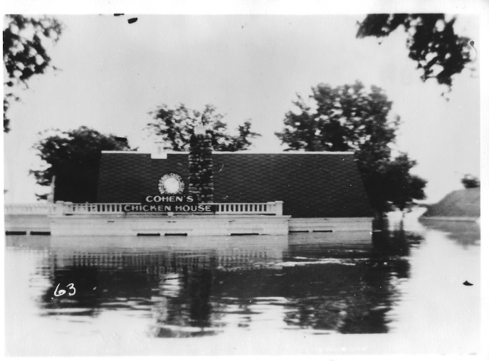
This picture was taken shortly
after the flood of 1951. The location was at the old Cohen’s Chicken restaurant
on Grant Avenue.
The
most recent of devastating floods occurred on Monday July 19th,
1993. The magnitude and timing of several rainstorms in mid-June and July 1993,
combined with wet antecedent conditions, were the principal causes of the
severe flooding in the upper Mississippi River Basin in 1993. The entirety of
the flood spanned nearly 2 months from mid-June to early August. By 11:45 on
that that same day the outflow the Milford dam was recorded at 22,500 cubic
feet per second, when the usual average release is 10- 12,000 cubic feet per
second. The first road to flood was Kansas highway 244 and then Kansas highway
57 followed suit. On the first day of the 1993 flood, 3,000 people were asked
to evacuate and only 1,500 took up the offer. As the flood got progressively
worse, more and more people were evacuated to shelters. Fifty deaths occurred in
all affected areas, except for Kansas, where not deaths were reported. Damages
approached $15 billion in the nine-State area of the Midwest.

This was an aerial picture taken
in 1993 of rural area being devastated by the flood.
Each
one of these past floods have left a unique imprint on the history of Geary
County and shaped the lives of many of the citizens who have lived in the
county. Unless Junction City moves location and changes its name, floods will
continue to be a very important part of its past and perhaps its future. There
is no way to predict any upcoming floods and we hope that the Milford and
Tuttle Creek dams can do their job and prevent any future floods. But as we
learned from the past, this community is resilient and can overcome any flood. have any comments of question? Comment down below and follow us on Facebook !
No comments:
Post a Comment